Source: Mapping Manicongo (1502)
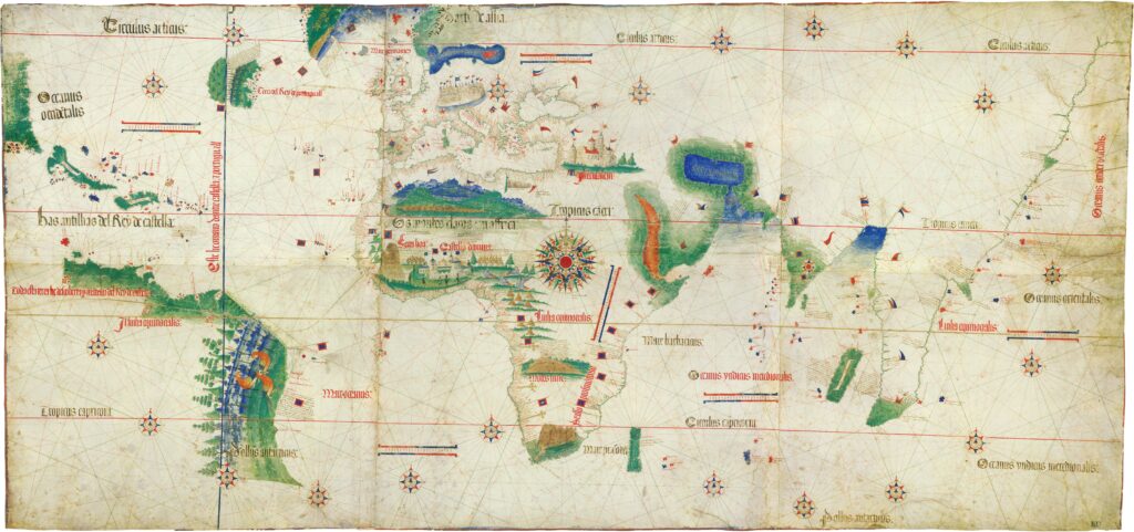
This world map was smuggled out of Portugal in 1502 by Alberto Cantino, an Italian agent in Lisbon, for his patron, Ercole d’Este, the Duke of Ferrara. Reflecting recent Portuguese expeditions in the Atlantic and Indian Oceans, it was the most accurate map of its time, particularly in its depiction of the coastlines of Africa, Brazil, and India.
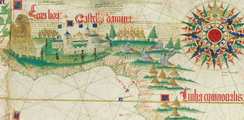
If the cities of Ambasse or Sonho[1] of Manicongo are represented on this map, they are the three huts located in what is now Gabon.[2] There are no illustrations of people in this area. The houses located directly to the north, which seem to represent Benin, are more defined and closely grouped together, representing a city. There are three people depicted under the perch of a bird.[3] Why they are positioned under this perch is obscure, but they are notably smaller and less animated than their neighbors surrounding the Casa da Mina[4] to the west, one of whom even wears attire. The only cities anywhere on the map that compete in size with São Jorge da Mina are Jerusalem and Venice, indicating its importance to the mapmaker. The houses located behind São Jorge da Mina, which represent Sierra Leone, are even more modern than those of Benin. This would give the European viewer of the map a sense that the Guinea region was more civilized, urbanized, and sovereign than the Congo region. The Portuguese did, indeed, go further inland in Manicongo than they did in the Guinea region, bypassing the royalty who were supposed to have acted as middlemen in the slave trade.[5]
[1] Mbanza-Kongo and Soyo of modern Angola.
[2] The Gabon River is marked as “Rio do gauam” on the map.
[3] The caption mentions papagayos, and the illustrations look like African grey parrots.
[4] Labeled “Castella damina” on the map.
[5] In 1526 King Affonso of Manicongo sent a letter to King João of Portugal complaining about being bypassed by merchants and about members of the free class being exploited as slaves. Brásio, Monumenta missionaria, 470. It is also noteworthy that Portugal held on to its colony in Angola until 1975, longer than any other mainland West African colony.
Translated by Timothy Allen. Portuguese text transcribed in “Cantino’s Chart, 1502” by E.G. Ravenstein, “The Voyages of Diogo Cão and Bartholomeu Dias, 1482-1488,” The Geographical Journal 16.6 (1900): 625-655. This translated CC BY-NC-ND 4.0.
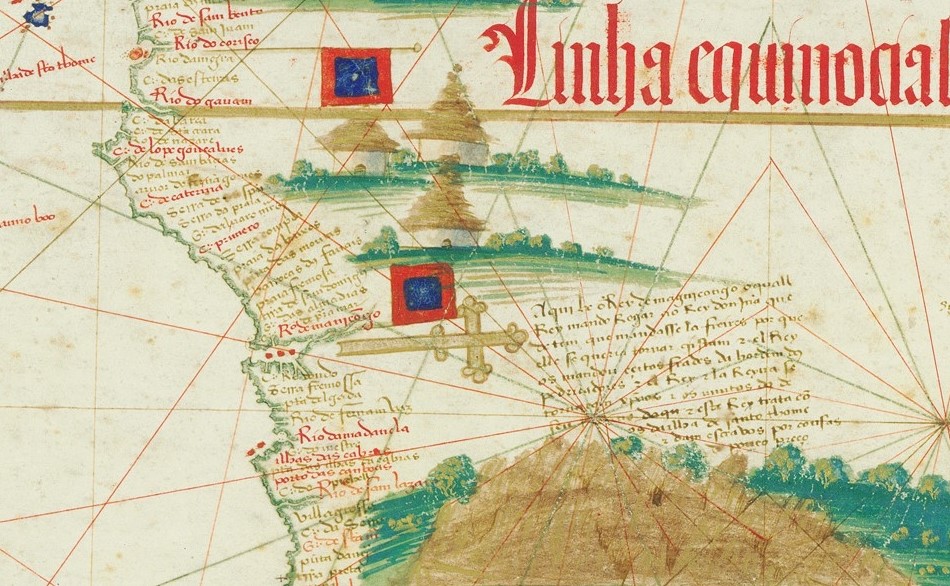
Here is the King of Manicongo, who is the king that sent a petition to the King Dom João[1] that he would send friars because he wanted to become a Christian. The King [of Portugal] sent them certain friars from the Order of Preachers.[2] The King and Queen [of Manicongo ] became Christians as did much of their population here. This king deals with those of Island of São Tomé and gives slaves for things of little value.[3]
[1] João II of Portugal (r.1481-1495).
[2] The Dominican Order.
[3] “Things of little value” could refer to many things, including luxury items like those sent to Pedro de Sousa, but one of them would be nzimbu shells. The Portuguese caused inflation by flooding the market with these once-valuable shells. Green, A Fistful of Shells, 226.
Discussion Questions
- According to the text from the map describing Manicongo, what was the main Portuguese motivation for colonizing Africa? What features on this map inside and outside of Africa might explain this focus on religion?
- Observe the location of flags across the entire map. What does this say about the need for the map to be smuggled out of Portugal?
- Portuguese Christians in the early sixteenth century used religious difference as a justification for enslaving non-Christians. How does the reference to slavery in this text relate to the references to religion?
Related Primary Sources
- The original Carta del Cantino in the Estense Digital Library.
- A public-domain image of this map is also available through Wikimedia.
- Introduction: Dom Pedro de Sousa and the BaKongo People Meet Portugal
- Order from João II to Rui Gil (1493)
- Testament of Álvaro de Caminha (1499)
- Letter from Pedro de Sousa to Manuel I (1513)
.jpg)
Recent Comments